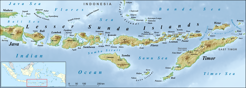
Soubor:Lesser Sunda Islands en.png
Z Multimediaexpo.cz

Velikost tohoto náhledu je: 800 × 286 pixelů
Obrázek ve vyšším rozlišení (rozměr: 3 361 × 1 200 pixelů, velikost souboru: 2,51 MB, MIME typ: image/png)
Mapa + Description:
- English: Map of Lesser Sunda Islands, including Bali, Lombok, Sumbawa, Flores, Lembata, Pantar, Sumba, Savu, Rote Island and Timor, also Wetar, the Kangean Islands, the Tengah Islands, the Sabalana Islands and the Selayar Islands
- Date: November 2017
- Source: own work, used:
- GMT and SRTM3V2
- Indonesia location map.svg by User:Uwe Dedering
- Dili, by U.S. Army Map Service
- Sedjorong, by U.S. Army Map Service
- Waikababubak, by U.S. Army Map Service
- Bima, by U.S. Army Map Service
- Ruteng, by U.S. Army Map Service
- Ende, by U.S. Army Map Service
- Pulau Lomblen, by U.S. Army Map Service
- Welu, by U.S. Army Map Service
- Ilwaki, by U.S. Army Map Service
- Baucau, by U.S. Army Map Service
- Bobonaro, by U.S. Army Map Service
- Pante Macassar, by U.S. Army Map Service
- Kupang, by U.S. Army Map Service
- Seba, by U.S. Army Map Service
- Baing, by U.S. Army Map Service
- Pulau Kalao, by U.S. Army Map Service
- Singaradja, by U.S. Army Map Service
- Waingapu, by U.S. Army Map Service
- Author: Lencer
+ pochází z Wikimedia Commons, kde má status – This file is licensed under the Creative Commons Attribution-Share Alike 3.0 Unported license. (CC BY-SA 3.0)
Historie souboru
Kliknutím na datum a čas se zobrazí tehdejší verze souboru.
| Datum a čas | Náhled | Rozměry | Uživatel | Komentář | |
|---|---|---|---|---|---|
| současná | 24. 6. 2021, 18:29 | 3 361×1 200 (2,51 MB) | Sysop (diskuse | příspěvky) | (Fotografie + ) |
- Editovat tento soubor v externím programu (Více informací najdete v nápovědě pro nastavení.)
Odkazy na soubor
Na soubor odkazuje tato stránka:
