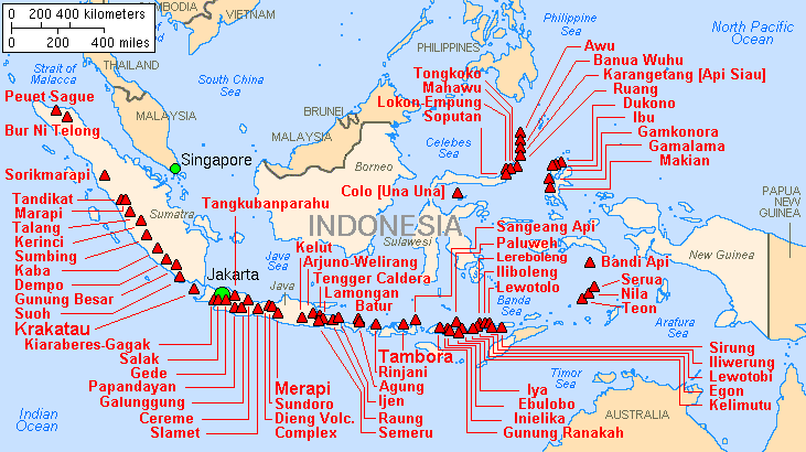
Soubor:Map indonesia volcanoes.gif
Z Multimediaexpo.cz
Mapa + Description: English: Major volcanoes of Indonesia, with eruptions since 1900 AD
- Date: 2001
- Author: Lyn Topinka, USGS; base map from CIA, 1997; volcanoes from Simkin and Siebert, 1994
+ pochází z Wikimedia Commons, kde má status – This image is in the public domain in the United States because it only contains materials that originally came from the United States Geological Survey, an agency of the United States Department of the Interior. For more information, see the official USGS copyright policy.
Historie souboru
Kliknutím na datum a čas se zobrazí tehdejší verze souboru.
| Datum a čas | Náhled | Rozměry | Uživatel | Komentář | |
|---|---|---|---|---|---|
| současná | 19. 2. 2018, 11:27 |  | 731×410 (25 kB) | Sysop (diskuse | příspěvky) | (Mapa + Kategorie:Maps of Indonesia) |
- Editovat tento soubor v externím programu (Více informací najdete v nápovědě pro nastavení.)
Odkazy na soubor
Na tento soubor neodkazuje žádná stránka.

