Soubor:Ruiz volcano.jpg
Z Multimediaexpo.cz

Velikost tohoto náhledu je: 703 × 599 pixelů
Obrázek ve vyšším rozlišení (rozměr: 3 997 × 3 408 pixelů, velikost souboru: 3,33 MB, MIME typ: image/jpeg)
Fotografie + Description:
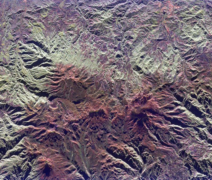
- Space radar image of Nevado del Ruiz
- Original Caption Released with Image:
- This spaceborne radar image shows the Ruiz-Tolima volcanic region in central Colombia, about 150 kilometers (93 miles) west of Bogata. The town of Manizales, Colombia, is the pinkish area in the upper right of the image. Ruiz Volcano, also known as Nevado del Ruiz, is the dark red peak below and right of the image center. A small circular summit crater is visible at the top of Ruiz. Tolima Volcano is the sharp peak near the lower left corner of the image. The red color of the image is due to the snow cover and the lack of vegetation at high elevations in these volcanic mountains. Ruiz Volcano, at 5,389 meters (17,681 feet) elevation, is capped by glaciers. In 1985, an explosive eruption melted parts of these glaciers, triggering mudflows along narrow canyons on the sides of the volcano. The town of Armero, located just off the right side of the image, was buried by mud and 21,000 residents were killed. Scientists are using radar images of these remote yet dangerous volcanoes to understand the threats they pose to local populations.
- The image was acquired by the Spaceborne Imaging Radar-C/X-band Synthetic Aperture Radar (SIR-C/X-SAR) onboard the space shuttle Endeavour on April 14, 1994. The image is centered at 4.8 degrees north latitude and 75.3 degrees west longitude. North is toward the upper right. The image shows an area 40 kilometers by 48 kilometers (24.8 miles by 29.8 miles). The colors are assigned to different frequencies and polarizations of the radar as follows: red is L-band, horizontally transmitted, horizontally received; green is L-band, horizontally transmitted, vertically received; blue is C-band, horizontally transmitted, vertically received. SIR-C/X-SAR, a joint mission of the German, Italian and United States space agencies, is part of NASA's Mission to Planet Earth program.
- Date: 14 April 1994
- Source: http://photojournal.jpl.nasa.gov/catalog/PIA01827 ID PIA01827
- Author: Picture from NASA
+ pochází z Wikimedia Commons, kde má status – This file is in the public domain in the United States because it was solely created by NASA.
NASA copyright policy states that "NASA material is not protected by copyright unless noted".
(Use of NASA logos, insignia and emblems is restricted per U.S. law 14 CFR 1221)
NASA copyright policy states that "NASA material is not protected by copyright unless noted".
(Use of NASA logos, insignia and emblems is restricted per U.S. law 14 CFR 1221)
Historie souboru
Kliknutím na datum a čas se zobrazí tehdejší verze souboru.
| Datum a čas | Náhled | Rozměry | Uživatel | Komentář | |
|---|---|---|---|---|---|
| současná | 7. 11. 2013, 15:19 |  | 3 997×3 408 (3,33 MB) | Sysop (diskuse | příspěvky) | (Fotografie + Sysop + pochází z Wikimedia Commons, kde má status – ) |
- Editovat tento soubor v externím programu (Více informací najdete v nápovědě pro nastavení.)
Odkazy na soubor
Na soubor odkazuje tato stránka:
