Soubor:Åland Political Map-fi.png
Z Multimediaexpo.cz

Velikost tohoto náhledu je: 595 × 600 pixelů
Obrázek ve vyšším rozlišení (rozměr: 1 000 × 1 008 pixelů, velikost souboru: 296 kB, MIME typ: image/png)
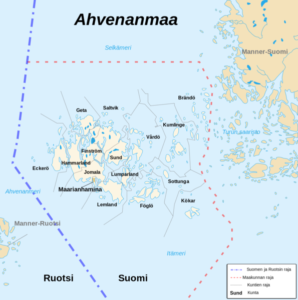
Mapa + English: Political map of the autonomous finnish province of Åland, in english.
- Shows the national, regional and municipal boundaries about Åland islands.
- Français: Carte politique de l'État libre associé d'Åland, en anglais.
- La carte montre les frontières internationales, régionales et municipales concernant l'archipel d'Åland.
- Date: 21 August 2007
- Author: Sémhur
+ pochází z Wikimedia Commons, kde má status – Creative Commons Attribution-Share Alike 4.0 International, 3.0 Unported, 2.5 Generic, 2.0 Generic and 1.0 Generic license.
Historie souboru
Kliknutím na datum a čas se zobrazí tehdejší verze souboru.
| Datum a čas | Náhled | Rozměry | Uživatel | Komentář | |
|---|---|---|---|---|---|
| současná | 20. 6. 2017, 11:00 |  | 1 000×1 008 (296 kB) | Sysop (diskuse | příspěvky) | (Fotografie + ) |
- Editovat tento soubor v externím programu (Více informací najdete v nápovědě pro nastavení.)
Odkazy na soubor
Na soubor odkazuje tato stránka:
