V pondělí 16. září 2024 začala naše další
nová soutěž o nejlepší webovou stránku !!
Proto neváhejte a začněte rychle soutěžit o lákavé ceny !!
nová soutěž o nejlepší webovou stránku !!
Proto neváhejte a začněte rychle soutěžit o lákavé ceny !!
Soubor:Pyrenees-Atlantiques topographic map-fr.jpg
Z Multimediaexpo.cz
(Rozdíly mezi verzemi)
(Fotografie + + pochází z Wikimedia Commons, kde má status – Kategorie:CC fotografie) |
(Doplnění) |
||
| Řádka 1: | Řádka 1: | ||
| - | + | Mapa + '''English''': Topographic map in French of the department of the Pyrénées-Atlantiques | |
| + | * This is a lighter raster JPG format version of Image:Pyrenees-Atlantiques_topographic_map-fr.svg which should be used in the article pages, the vector graphics version purpose being for modification and / or translation. | ||
| + | Approximate scales : | ||
| + | * Topographic data : 1:400,000 (accuracy : about 100 m) ; | ||
| + | * Bathymetry : 1:4 000 000 (accuracy : about 1,000 m) | ||
| + | * '''Français''': Carte topographique en français du département des Pyrénées-Atlantiques | ||
| + | Ceci est une version bitmap au format JPG et de poids de fichier plus léger de Image:Pyrenees-Atlantiques_topographic_map-fr.svg qui devrait être utilisée dans les pages d'articles, la version vectorielle SVG étant destinée à faciliter les modifications et / ou traductions. | ||
| + | Échelles approximatives : | ||
| + | * Données topographiques : 1:400 000 (précision : environ 100 m) : | ||
| + | * Bathymétrie : 1:4 000 000 (précision : environ 1 000 m) | ||
| + | * Approximate geographic limits of the map (15" close) : | ||
| + | ** SW corner : 42°41'N – 01°53'W | ||
| + | ** S-center latitude : 42°41'30"N | ||
| + | ** SE corner : 42°41'N – 00°07'E | ||
| + | ** NE corner : 43°41'N – 00°08'E | ||
| + | ** NW corner : 43°41'N – 01°54'W | ||
| + | * Date: March 2008 | ||
| + | * Author: Eric Gaba (Sting - fr:Sting) | ||
| - | + pochází z Wikimedia Commons, kde má status – | + | + pochází z Wikimedia Commons, kde má status – Creative Commons Attribution-Share Alike 4.0 International, 3.0 Unported, 2.5 Generic, 2.0 Generic and 1.0 Generic license. |
[[Kategorie:CC fotografie]] | [[Kategorie:CC fotografie]] | ||
| + | [[Kategorie:Maps of France]] | ||
Aktuální verze z 12. 2. 2017, 12:25
Mapa + English: Topographic map in French of the department of the Pyrénées-Atlantiques
- This is a lighter raster JPG format version of Image:Pyrenees-Atlantiques_topographic_map-fr.svg which should be used in the article pages, the vector graphics version purpose being for modification and / or translation.
Approximate scales :
- Topographic data : 1:400,000 (accuracy : about 100 m) ;
- Bathymetry : 1:4 000 000 (accuracy : about 1,000 m)
- Français: Carte topographique en français du département des Pyrénées-Atlantiques
Ceci est une version bitmap au format JPG et de poids de fichier plus léger de Image:Pyrenees-Atlantiques_topographic_map-fr.svg qui devrait être utilisée dans les pages d'articles, la version vectorielle SVG étant destinée à faciliter les modifications et / ou traductions. Échelles approximatives :
- Données topographiques : 1:400 000 (précision : environ 100 m) :
- Bathymétrie : 1:4 000 000 (précision : environ 1 000 m)
- Approximate geographic limits of the map (15" close) :
- SW corner : 42°41'N – 01°53'W
- S-center latitude : 42°41'30"N
- SE corner : 42°41'N – 00°07'E
- NE corner : 43°41'N – 00°08'E
- NW corner : 43°41'N – 01°54'W
- Date: March 2008
- Author: Eric Gaba (Sting - fr:Sting)
+ pochází z Wikimedia Commons, kde má status – Creative Commons Attribution-Share Alike 4.0 International, 3.0 Unported, 2.5 Generic, 2.0 Generic and 1.0 Generic license.
Historie souboru
Kliknutím na datum a čas se zobrazí tehdejší verze souboru.
| Datum a čas | Náhled | Rozměry | Uživatel | Komentář | |
|---|---|---|---|---|---|
| současná | 12. 2. 2017, 11:46 | 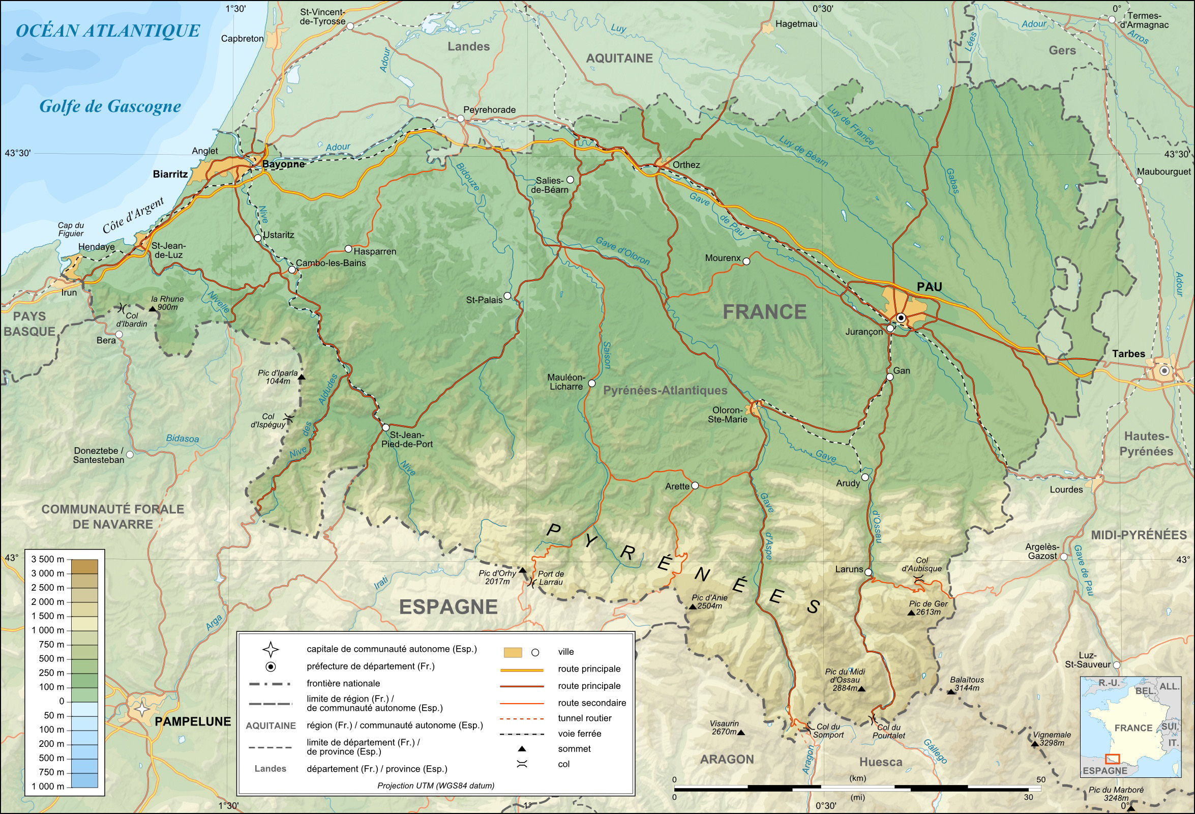 | 2 350×1 600 (1,23 MB) | Sysop (diskuse | příspěvky) | (Fotografie + + pochází z Wikimedia Commons, kde má status – Kategorie:CC fotografie ) |
- Editovat tento soubor v externím programu (Více informací najdete v nápovědě pro nastavení.)
Odkazy na soubor
Na soubor odkazuje tato stránka:


