V sobotu 2. listopadu proběhla mohutná oslava naší plnoletosti !!
Multimediaexpo.cz je již 18 let na českém internetu !!
V tiskové zprávě k 18. narozeninám brzy najdete nové a zásadní informace.
Multimediaexpo.cz je již 18 let na českém internetu !!
V tiskové zprávě k 18. narozeninám brzy najdete nové a zásadní informace.
Soubor:Scutum constellation map.png
Z Multimediaexpo.cz
(Rozdíly mezi verzemi)
(Astronomická mapa + English: + pochází z Wikimedia Commons, kde má status – GNU Free Documentation License, Version 1.2 or any later version. Kategorie:GNU fotografie Kategorie:Constellations maps) |
(+ Doplnění) |
||
| Řádka 1: | Řádka 1: | ||
| - | Astronomická mapa + English: | + | Astronomická mapa + English: This is a celestial map of the constellation Scutum, the Shield. |
| + | * Copyright © 2003 Torsten Bronger. | ||
| + | * It was created by Torsten Bronger using the program PP3 on 2003/08/18. At PP3's homepage, you also get the input scripts necessary for re-compiling the map. | ||
| + | * The yellow dashed lines are constellation boundaries, the red dashed line is the ecliptic, and the shades of blue show Milky Way areas of different brightness. The map contains all Messier objects, except for colliding ones. The underlying database contains all stars brighter than 6.5. All coordinates refer to equinox 2000.0. | ||
| + | * The map is calculated with the equidistant azimuthal projection (the zenith being in the center of the image). The north pole is to the top. The (horizontal) lines of equal declination are drawn for 0°, ±10°, ±20° etc. The lines of equal rectascension are drawn for all 24 hours. Towards the rim there is a very slight magnification (and distortion). | ||
| - | + pochází z Wikimedia Commons, kde má status – GNU Free Documentation License, Version 1.2 or any later version | + | + pochází z Wikimedia Commons, kde má status – GNU Free Documentation License, Version 1.2 or any later version published by the Free Software Foundation; |
[[Kategorie:GNU fotografie]] | [[Kategorie:GNU fotografie]] | ||
[[Kategorie:Constellations maps]] | [[Kategorie:Constellations maps]] | ||
Aktuální verze z 16. 4. 2015, 21:33
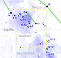
Astronomická mapa + English: This is a celestial map of the constellation Scutum, the Shield.
- Copyright © 2003 Torsten Bronger.
- It was created by Torsten Bronger using the program PP3 on 2003/08/18. At PP3's homepage, you also get the input scripts necessary for re-compiling the map.
- The yellow dashed lines are constellation boundaries, the red dashed line is the ecliptic, and the shades of blue show Milky Way areas of different brightness. The map contains all Messier objects, except for colliding ones. The underlying database contains all stars brighter than 6.5. All coordinates refer to equinox 2000.0.
- The map is calculated with the equidistant azimuthal projection (the zenith being in the center of the image). The north pole is to the top. The (horizontal) lines of equal declination are drawn for 0°, ±10°, ±20° etc. The lines of equal rectascension are drawn for all 24 hours. Towards the rim there is a very slight magnification (and distortion).
+ pochází z Wikimedia Commons, kde má status – GNU Free Documentation License, Version 1.2 or any later version published by the Free Software Foundation;
Historie souboru
Kliknutím na datum a čas se zobrazí tehdejší verze souboru.
| Datum a čas | Náhled | Rozměry | Uživatel | Komentář | |
|---|---|---|---|---|---|
| současná | 6. 11. 2013, 10:17 |  | 1 789×1 709 (199 kB) | Sysop (diskuse | příspěvky) | (Astronomická mapa + English: + pochází z Wikimedia Commons, kde má status – GNU Free Documentation License, Version 1.2 or any later version. Kategorie:GNU fotografie Kategorie:Constellations maps) |
- Editovat tento soubor v externím programu (Více informací najdete v nápovědě pro nastavení.)
Odkazy na soubor
Na soubor odkazují tyto 2 stránky:
