Čekání na nový webový server Multimediaexpo.cz skončilo !
Motorem našeho webového serveru bude pekelně rychlý
procesor AMD Ryzen Threadripper 7960X (ZEN 4).
Motorem našeho webového serveru bude pekelně rychlý
procesor AMD Ryzen Threadripper 7960X (ZEN 4).
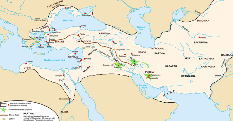
Soubor:Map achaemenid empire en.png
Z Multimediaexpo.cz

Velikost tohoto náhledu je: 800 × 415 pixelů
Obrázek ve vyšším rozlišení (rozměr: 1 676 × 869 pixelů, velikost souboru: 376 kB, MIME typ: image/png)
Mapa + Description:
- EN: Achaemenid Empire at its maximum extent
- Inspired by Historical Atlas of Georges Duby (p.11, map D), this map was made by Fabienkhan the 24th of August 2006, using Inkscape and GIMP.
- FR: Extension maximale de l'empire Achéménide
- Inspiré par l'Atlas historique de Georges Duby (Page 11, carte D), cette carte à été conçue par Fabienkhan le 24 août 2006 à l'aide d'Inkscape et de GIMP.
- Date: 31 August 2006 (original upload date)
- Author: Fabienkhan
+ pochází z Wikimedia Commons, kde má status – This file is licensed under the Creative Commons Attribution-Share Alike 2.5 Generic, 2.0 Generic and 1.0 Generic license.
Historie souboru
Kliknutím na datum a čas se zobrazí tehdejší verze souboru.
| Datum a čas | Náhled | Rozměry | Uživatel | Komentář | |
|---|---|---|---|---|---|
| současná | 12. 1. 2020, 14:19 |  | 1 676×869 (376 kB) | Sysop (diskuse | příspěvky) | (Mapa + Description: * EN: Achaemenid Empire at its maximum extent ** Inspired by Historical Atlas of Georges Duby (p.11, map D), this map was made by Fabienkhan the 24th of August 2006, using Inkscape and GIMP. * FR: Extension maximale de l'empire Achém�) |
- Editovat tento soubor v externím programu (Více informací najdete v nápovědě pro nastavení.)
Odkazy na soubor
Na soubor odkazuje tato stránka:
