The English encyclopedia Allmultimedia.org will be launched in two phases.
The final launch of the Allmultimedia.org will take place on February 24, 2026
(shortly after the 2026 Winter Olympics).
Dovolená : 23. prosinec 2025 — 29. prosinec 2025
Holidays : December 23, 2025 — December 29, 2025
The final launch of the Allmultimedia.org will take place on February 24, 2026
(shortly after the 2026 Winter Olympics).
Dovolená : 23. prosinec 2025 — 29. prosinec 2025
Holidays : December 23, 2025 — December 29, 2025
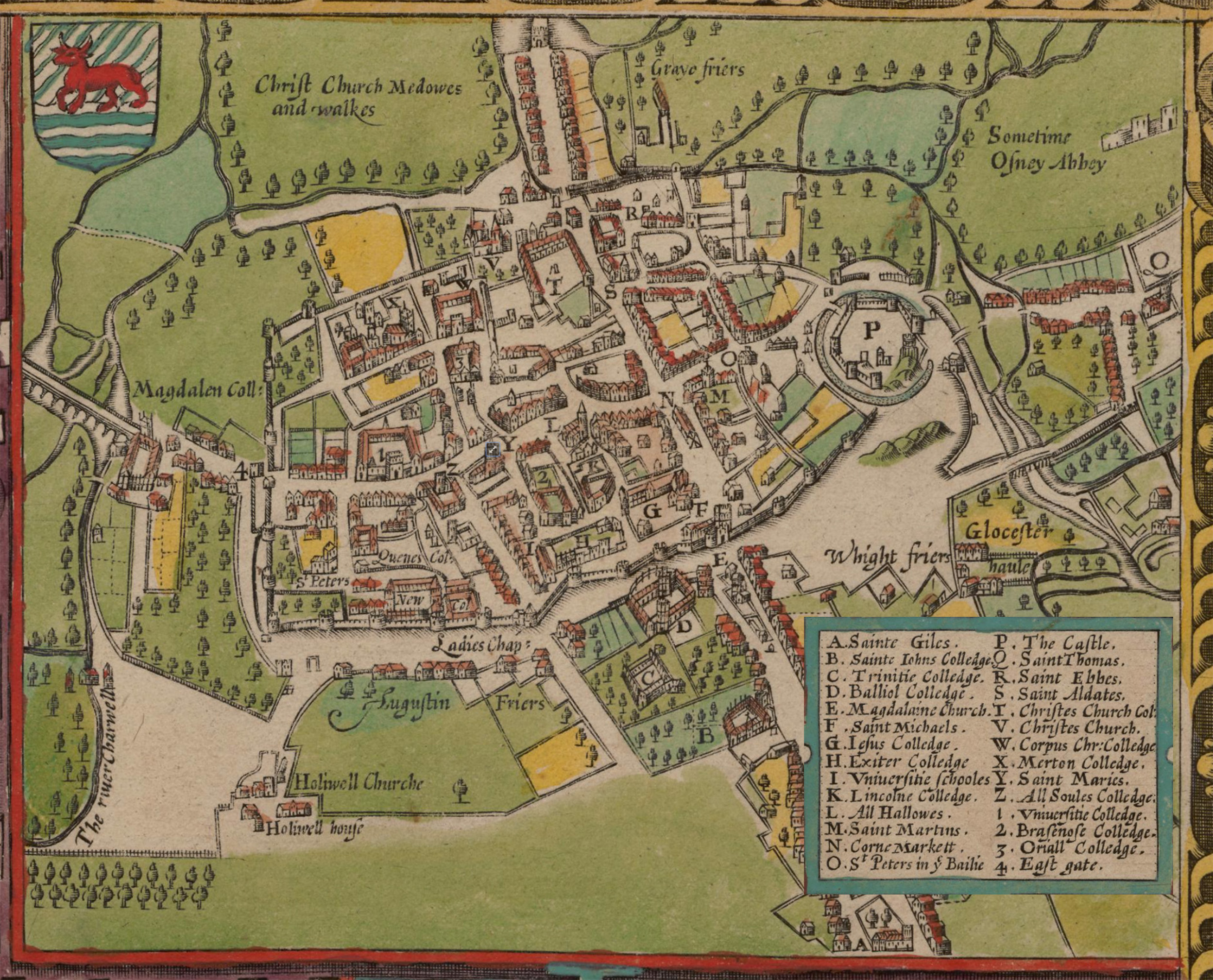
Soubor:John Speed's map of Oxford, 1605.jpg
Z Multimediaexpo.cz
Velikost tohoto náhledu je: 742 × 600 pixelů
Obrázek ve vyšším rozlišení (rozměr: 2 497 × 2 018 pixelů, velikost souboru: 1,5 MB, MIME typ: image/jpeg)
Mapa + Description:
- English: John Speed's map of Oxford, 1605. North is at the bottom. Oxford is still a walled city, but there some buildings are outside the walls, including Magdalen College.
- "P" is Oxford Castle
- "N" is Oxford's central crossroads at the junction of the High Street and St Aldates. Broad Street and Holywell Street now run along the line of the north (that is bottom) wall.
- Date: 1605
- Source: The Digital Revolution: Changing Oxford. Map is in the Bodleian Library.
- Author: John Speed (1542–1629)
+ pochází z Wikimedia Commons, kde má status – This work is in the public domain in its country of origin and other countries and areas where the copyright term is the author's life plus 100 years or less.
Historie souboru
Kliknutím na datum a čas se zobrazí tehdejší verze souboru.
| Datum a čas | Náhled | Rozměry | Uživatel | Komentář | |
|---|---|---|---|---|---|
| současná | 7. 7. 2025, 08:20 | | 2 497×2 018 (1,5 MB) | Sysop (diskuse | příspěvky) | (Fotografie + ) |
- Editovat tento soubor v externím programu (Více informací najdete v nápovědě pro nastavení.)
Odkazy na soubor
Na soubor odkazuje tato stránka:


