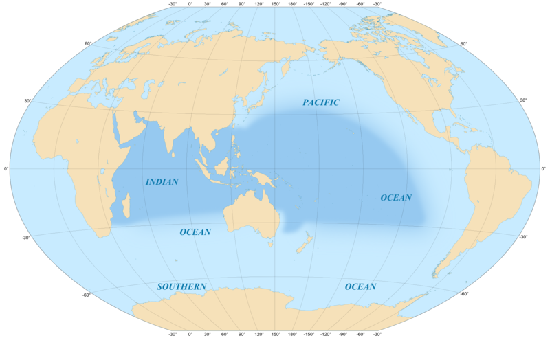
Soubor:Indo-Pacific biogeographic region map-en.png
Z Multimediaexpo.cz

Velikost tohoto náhledu je: 800 × 492 pixelů
Obrázek ve vyšším rozlišení (rozměr: 1 950 × 1 200 pixelů, velikost souboru: 634 kB, MIME typ: image/png)
Mapa + Description:
- English: Map in English of the area covered by the Indo-Pacific biogeographic region.
- Scale: 1:5,000,000
- Français: Carte en anglais de la zone couverte par la région biogéographique du bassin Indo-Pacifique.
- Échelle: 1:5 000 000.
- Winkel Tripel projection, WGS84 datum, central meridian : 150°E.
- Date: May 2008
- Source:
- Coast lines : U.S. NGDC World Coast Line ;
- Reference for the limits of the Indo-Pacific biogeographic region : Spalding, Mark D., Helen E. Fox, Gerald R. Allen, Nick Davidson et al. "Marine Ecoregions of the World: A Bioregionalization of Coastal and Shelf Areas". Bioscience Vol. 57 No. 7, July/August 2007, pp. 573-583, available through the World Wildlife Fund's site
- Author: Eric Gaba (Sting - fr:Sting)
+ pochází z Wikimedia Commons, kde má status – This file is licensed under the Creative Commons Attribution-Share Alike 4.0 International, 3.0 Unported, 2.5 Generic, 2.0 Generic and 1.0 Generic license.
Historie souboru
Kliknutím na datum a čas se zobrazí tehdejší verze souboru.
| Datum a čas | Náhled | Rozměry | Uživatel | Komentář | |
|---|---|---|---|---|---|
| současná | 25. 11. 2023, 22:53 |  | 1 950×1 200 (634 kB) | Sysop (diskuse | příspěvky) | (Fotografie + ) |
- Editovat tento soubor v externím programu (Více informací najdete v nápovědě pro nastavení.)
Odkazy na soubor
Na soubor odkazuje tato stránka:
